 |
|
| www.BananaWind.us |
The sea is the same as it has been since before men ever went on it in boats. - Ernest Hemingway |
|
|
|
| www.BananaWind.us |
The sea is the same as it has been since before men ever went on it in boats. - Ernest Hemingway |
| With all the charts, gadgets, and electronic devices onboard, sometimes the most valuable asset is a well trained eye. |
|
1. |
Estimating
Angles
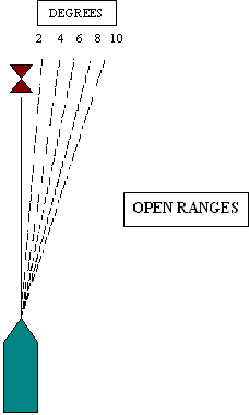
It is not always necessary to take a bearing of an object using a hand-bearing compass. Often it is enough to estimate the angle by "eyeing" it across the binnacle compass. You can also use the bow of the boat (as 12 o'clock) and mentally measure the angle in relation to the bow. |
|||||||||||||||||||||||||||||||||||||
| 2. | Lines
of Positions
Lines of positions with objects on shore and the edges of islands are often all you need to successfully navigate short distances. |
|||||||||||||||||||||||||||||||||||||
| 3. |
|
|||||||||||||||||||||||||||||||||||||
| 4. |
Three Finger Rule
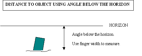
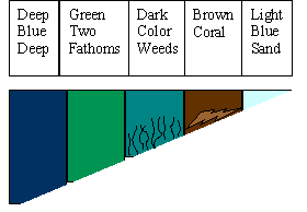
Similar to using your fingers to determine the angle of a range, you can also use the width of your fingers to determine the height of a charted object on shore (e.g. a lighthouse), and then use the angle and height of the object to determine your distance from the object. An object makes a 6 degree vertical angle at a distance 10 times its height.
|
|||||||||||||||||||||||||||||||||||||
| 5. |
|
|||||||||||||||||||||||||||||||||||||
| 6. |
|
|||||||||||||||||||||||||||||||||||||
| 7. |
|
|||||||||||||||||||||||||||||||||||||
| 8. |
Buildings on Shore
Within 3 miles of shore, you can see the windows in buildings. When beyond 3 miles, you can only see the outlines of buildings. |
|||||||||||||||||||||||||||||||||||||
| 9. |
Distance to the Horizon
Nautical miles = 1.144 X square root of the height of eye (in feet) above the waterline. Statute miles = 1.5 X square root of the height of eye (in feet) above the waterline. |
|||||||||||||||||||||||||||||||||||||
| 10. |
|
|||||||||||||||||||||||||||||||||||||
| 11. |
Departure Fix
Take a good departure fix when leaving a port (either electronic or manual). It is this departure fix from which you will relate the rest of the voyage. |
|||||||||||||||||||||||||||||||||||||
| 12. |
|
|||||||||||||||||||||||||||||||||||||
| 13. |
Night Vision
It takes 15 minutes for the eyes to totally adjust to the dark. A red light (such as a "stop light" used in photography) does not cause night blindness. Red or green buoy lights are visible at 4 - 5 nautical miles at night. White buoy lights are visible slightly farther than 4 - 5 nautical miles at night. Lights from a lighted buoy are discernable at only 2 - 3 nautical miles during the day. (The buoy itself is normally visible in the day long before the light can be discerned.) |
|||||||||||||||||||||||||||||||||||||
| 14. |
Maximum Range for Seeing
Lighthouse on the Horizon
1. Calculate distance to horizon for lighthouse (1.144 X square root of lighthouse height in feet.) 2. Calculate distance to horizon for the boat (1.144 X square root of height of eye of observer in feet.) 3. Add the two distances. This is the maximum distance (in nautical miles) at which you can first see the lighthouse over the horizon.
|
|||||||||||||||||||||||||||||||||||||
| 15. |
Binoculars
7X (power) binoculars are the maximum for use on a boat (due to the motion of the boat), but 6X (power) binoculars are better. For night use, the objective lens should be at least five times the power. (e.g. 6X binoculars should have an objective lens of 30 mm for night use.) |
|||||||||||||||||||||||||||||||||||||
| 16. |
|
|||||||||||||||||||||||||||||||||||||
| 17. |
Computing Boat Speed
1. Wood Chip Method Drop floating wood chips off the bow and record the time it takes them to reach the stern. Use the formula: Length of boat (in feet) ÷ recorded time of the wood chips (in seconds) X 0.5925 knots (0.5925 knots = 1 foot/second) = boat speed in knots.
Take several readings
and calculate an average to get a more accurate boat speed.
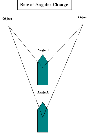
2. Distance-Time Angular Method
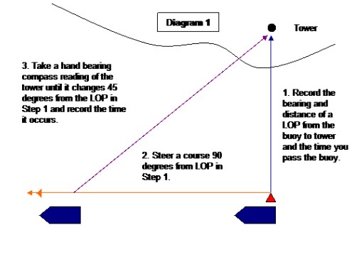
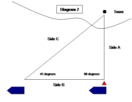
You have created a right triangle with Side A being the distance from the buoy to the tower and Side B being the distance you traveled until the angle forming Side C became 45 degrees. Since it is a right triangle, Side A = Side B; therefore, you already know the distance you traveled (i.e. Side B) from the chart measurements in Step 1 (i.e. Side A). With that information and the time in minutes it took you to traverse Side B, you can calculate your speed using the following formula: Speed in knots = [(Distance of Side A in nautical miles) X (60 minutes)] ÷ (Minutes to travel Side B) Example: The distance from an island to a coastal tower shown on a chart is 2 nautical miles. You draw a LOP from the island to the tower, measure the distance, and determine a course setting 90 degrees from the LOP. You sail as close to the island as possible on your determine course and take your readings. The time it takes you to travel to the 45 degree change reading is 30 minutes. How fast were you traveling? [(2 nautical miles) X (60 minutes)] ÷ (30 minutes) = 4 nautical miles per hour or 4 knots
3. Tennis Ball Method (Source: The Complete Sailor)
|
|||||||||||||||||||||||||||||||||||||
| 18. |
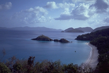
Clouds
Stationary clouds form over mountainous islands during the day. They can be a sign of land. Low level cumulus clouds form above and inland from a beach on a warm sunny day with an onshore breeze. |
|||||||||||||||||||||||||||||||||||||
| 19. |
Birds
Land birds fly away from land during the day. Land birds fly toward land in the evening. |
|||||||||||||||||||||||||||||||||||||
| 20. |
Potato Navigation
When in fog, throw potatoes from the bow every 30 seconds. A splash indicates that everything is clear. A thud indicates you are too close to land or some obstruction. |
|||||||||||||||||||||||||||||||||||||
| 21. |
Distance to a Storm
In nautical miles = Number of seconds between lightning & thunder ÷ 5.5 In statute miles = Number of seconds between lightning & thunder ÷ 5 |
![]()
 |
 |
The Last Priest available at TheLastPriest.com