Basic Navigation
| You may be
able to sail faster than anyone else or turn your boat on a dime, but
all the boat handling skills in the world won't help you if you don't
know how to get safely to where you want to go. |
Use this page in conjunction with Basic
Chartwork.
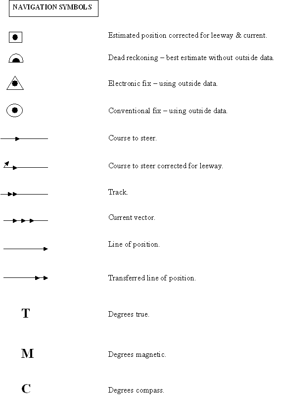
Navigation Symbols
Charts
| The
scales of nautical charts range from 1:2,500 to about 1:5,000,000.
Graphic scales are generally shown on charts with scales of 1:80,000 or
larger, and numerical scales are given on smaller scale charts. National
Ocean Service (NOS) charts are classified according to scale as follows:
Sailing charts--scales
1:600,000 and smaller are for use in fixing the mariner's position as he
approaches the coast from the open ocean, or for sailing between distant
coastwise ports.
General charts--scales
1:150,000 to 1:600,00 are for coastwise navigation outside outlying
reefs and shoals.
Coast charts--scales
1:50,000 to 1:150,000 are for inshore navigation leading to bays and
harbors of considerable width and for navigating large inland waterways.
Harbor charts--scales
larger than 1:50,000 are for harbors, anchorage areas, and the smaller
waterways.
Special
charts--various scales, cover the intercostals and
miscellaneous small-craft areas.
|
Soundings
on foreign charts
Most
modern charts use the metric system, but old charts use these
measures:
English
fathom - 6 feet
Danish
favn - 6.176 feet
Dutch
vadem - 5.905 feet
Norwegian
favn - 6.176 feet
Russian
sazhene - 6 feet
Spanish
braza - 5.492 feet
Swedish
famn - 5.844 feet |
|
Bearings
| A
compass rose on a chart will show both true north and magnetic north,
but the magnetic bearings vary with the passage of time, hence the term
"variation." A navigator must always know which
set of bearings he is dealing with (e.g. true, magnetic, compass). So as
to not mistakenly confuse them when navigating, it is often best to
choose one system and stick with it. You can convert from one to
another by remembering the phrase "True Virgins Make Dull
Companions." |
|
True
Virgins Make Dull Companions
T
+ V
= M
+ D =
C
True
+ Variation = Magnetic
+ Deviation = Compass
When
dealing with variation and deviation remember "West is Best"
and "East is Least," meaning you add when it is West and
subtract when it is East.
Variation
is recorded on the compass rose on the chart.
Deviation
must be manually calculated for each compass onboard. |
|
Example:
The
bearings are 240 degrees True with 7 degrees West variation and 4
degrees East deviation.
T + V =
M + D = C
240 T +
7 V (West is Best) = 247 M - 4 D (East is Least) = 243 C
You
would then steer 243 degrees using your boat compass in order to proceed
240 true degrees. |
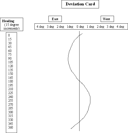
Deviation
| Large
metal objects onboard, such as a diesel engine, generate magnetic fields
that will affect the accuracy of a boat compass. This effect is
referred to Deviation, and it will change at different points of
sail. You can have the deviation of your binnacle compass
professionally determined, and you can do it yourself, although it might
not be as accurate as having it professionally done. Determining
deviation is referred to as "Swinging Ship." The result
is a Deviation Card that indicates the deviation at each point of sail. |
Deviation Card
1.
Create a card like the one displayed.
2.
Sail the boat at each heading listed on the card using the binnacle
compass to determine the correct heading.
3.
While on each heading, also record what a hand compass determines the
heading to be. Have the person using the hand compass stand as far
away as possible from the engine and any other metal object. The
best place is at the bow of the boat.
4.
After sailing through all the headings (i.e. swinging the ship), subtract
the compass reading from the binnacle reading for each heading. If
the number is positive, it is West (west is best). If the difference
is negative, it is East (east is least). For example: 90
(binnacle) - 87 (hand) = + 3 (West); 240 (binnacle) - 244 (hand) = -
4 (East).
5.
Plot the differences for each point of sail on the deviation card and draw
a line to connection the points. |
|
Using the Deviation Card
1.
Calculate the Magnetic course (True +Variation = Magnetic).
2.
Look at the card for the deviation for that particular heading.
3.
Add the deviation for a West correction, and subtract the deviation for an
East correction.
4.
Use the binnacle compass to steer a course based on the deviation calculation
(Magnetic + Deviation = Compass). For example, if the course is 90
degrees and the deviation is 3 degrees West, steer 93 degrees. |
Dead Reckoning
| Dead
Reckoning (or Ded Reckoning) is the process of using time and speed to
"deduce" (hence the term "ded" reckoning) your
position based on advancing from a known position. You chart a
course, and then at regular intervals, you determine your position along
that course line using dead reckoning.
At some predetermined
point (or when circumstances present themselves), you take a
"fix" to determine your actual position and compare it to your
dead reckoned position. From there you chart a new course from the
actual "fixed" position, making allowances for conditions that
may have caused you to veer from your original charted course (e.g.
current, leeway, etc.)
|
Time & Distance Calculation
|
D = ST
Distance
(in nautical miles) = Speed (in knots) X Time (in hours)
For
example: Traveling at 6 knots for 2 hours = 6 X 2 = 12 nautical
miles
If you
wish to record time in minutes instead of hours, use the formula 60D =
ST
Remember
the formula as "60 D Street" (i.e. 60 D = ST) |
|
Minutes
per Nautical Mile
To calculate the
number of minutes it will take to travel 1 nautical mile, divide 60 by
the speed in knots:
Minutes to travel 1
nautical mile = 60 ÷ speed in knots
For example:
60 ÷ 2
knots = 30 minute nautical mile
60 ÷ 3
knots = 20 minute nautical mile
60 ÷ 4
knots = 15 minute nautical mile
60 ÷ 6
knots = 10 minute nautical mile |
| Speed |
Minutes
per N.M. |
| 3
knots |
20
minutes |
| 4
knots |
15
minutes |
| 4.3
knots |
14
minutes |
| 4.6
knots |
13
minutes |
| 5
knots |
12
minutes |
| 5.5
knots |
11
minutes |
| 6
knots |
10
minutes |
| 6.7
knots |
9
minutes |
| 7.5
knots |
8
minutes |
| 8.6
knots |
7
minutes |
| 10
knots |
6
minutes |
|
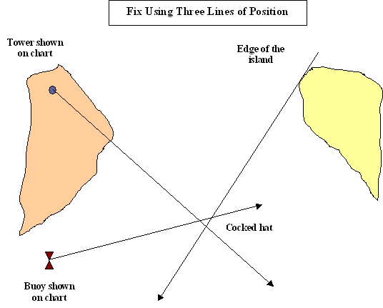
Fixes and Lines of Position
| To
check the accuracy of your calculated position using time & distance
(i.e. dead reckoning), you must take a "fix" of your actual
position. Fixes can be taken from nearby objects using lines of
position. You can also take an electronic fix using a GPS. |
|
Lines
of Position from Charted Objects
Fixes
are taken using a hand bearing compass.
Fixes are
better with nearby objects.
Tangent
lines from the sides of islands also serve as good lines of position.
Take fore
and aft bearings first.
Take the
side bearings last.
Use three
lines of position, ideally 60 degrees apart.
The center
triangle where they intersect (called a "cocked hat") is the
position of the boat.
The average
error for a line of position is 5 - 6 degrees, and the error increases with the distance from the
objects. |
|
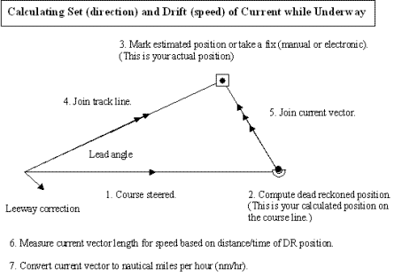
Calculating Current Using Dead
Reckoning and a Fix
| Currents
are usually stronger in deeper water. When moving against a
current in a channel, stay to the sides. When moving with a
current in a channel, stay in the middle. Many underestimate the
strength of a current and its affect on navigation. This is
especially true of the Gulf Stream that can be 4 knots or more.
By computing a dead
reckoned position and taking a fix, you can calculate the set and
drift of a current. |
|
1.
Plot a course and travel along it for 1 hour.
2.
Compute a dead reckoned position along that course.
3.
Take a fix and mark your actual position.
4.
Join a track line to your actual position.
5.
Join a current vector from your dead reckoned position to your fixed
position. This is the set (direction) of the current.
6.
Use your dividers to measure the current vector, and use the
latitude markings to determine distance in minutes. Since
you've traveled 1 hour, the length of the current vector is the drift
(speed) of the current in knots. |
 |
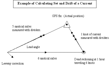
|
Example
You travel for one
hour at 6 knots.
Your dead reckoned
position is 6 nautical miles down the course line.
You take a GPS fix
and mark your actual position. Your track line shows that you've
traveled 5 nautical miles down the track, less than the 6 nautical
mile shown on the course line due to the effect of the current.
You connect the
current vector and measure it with your dividers. It measures
1 minute of latitude; therefore, its drift is 1 knot. |
 |
|
When
the current is 90 degrees to the boat, you can do a quick calculation
of the lead angle.
Lead
angle = (60 X current in knots) ÷ speed in knots |
Dead Reckoning Error
| Dead
reckoning error is normally about 10%, and you can allow for this by
drawing circles of uncertainty on the chart around your dead reckoned
positions.
Since a boat covers
a nautical distance in one hour equal to its speed in knots, you would
allow a 10% margin of error for each hour.
For
example:
At 6 knots, you
would have a .6 nautical mile error potential in the first hour.
At 6 knots, you
would have a 1.2 nautical mile error potential in the second hour.
At 6 knots, you
would have a 1.8 nautical mile error potential in the third hour.
That is why you need
to take regular fixes because the error potential of dead reckoning
steadily increases with time. |
Estimated Time to a Mark
Since
dead reckoning is accurate only to 10% of the distance, it is possible
that you could miss an mark to which you are sailing.
You
therefore need to keep track of your estimated time in route to know
when you should be encountering the mark. Before leaving, you
should calculate your estimated time to the mark.
When 5
minutes have past and you have not encountered the mark, you need to
begin a search pattern to find it (if finding it is crucial to your
safe passage).
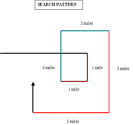
Searching
for a mark (or even for a man overboard) involves an expanding
square. You can use the shoreline and water depth contours for
reference. With such a pattern, you are never more than one mile
from a prior pass. |
|
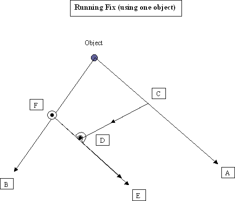
Running Fix
|
It
is also possible to take a "running fix" using only one
object. A running fix is not terribly accurate, but it is better
than nothing. If there is a current, it is of limited
reliability.
A. Take the
first line of position (LOP) from a charted object, and record the
time.
B. Travel a
distance and take a second LOP. Record the time.
C. Pick a
point anywhere along the first LOP.
D. Based on
speed, direction and time, do a dead reckoning (DR) from the time of
the first LOP to the time of the second LOP. Draw a course line
from the first LOP to the DR point.
E. Draw a transferred
LOP through the DR point parallel to the first LOP.
F. Where the
transferred LOP intersects the second LOP is the fix. |
 |
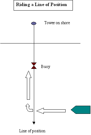
Riding a Line of Position
|
When
unable to find a mark but able to see a charted object on the shore,
you can ride a line of position until you find the mark.
1. Identify a
charted object on shore.
2. Draw a line
of position from the object on shore through the mark.
3. Move to the
bearing of the line of position and steer toward the object until the
mark is located. |
|
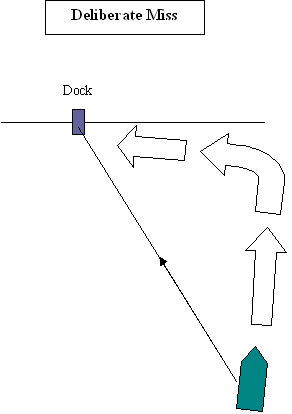
Deliberate Miss
|
When
sailing directly toward a destination, an error might put you off
course, and make you miss your mark. You then might not know
which way to proceed.
Instead, you can
deliberately miss the mark and then know in which direction to
proceed.
1. Set a
course directly to a destination.
2. Veer off
shortly before arriving.
3. Follow the
shoreline to the destination. |
|
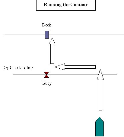
Running the Contour
|
Running
the contour is especially helpful when navigating in times of low
visibility, such as fog.
1. Perform a
deliberate miss of the destination, but know which side of the mark
you are on.
2. Use the
depth sounder and the depth contour lines of the chart to
proceed along the shore to the destination. |
|
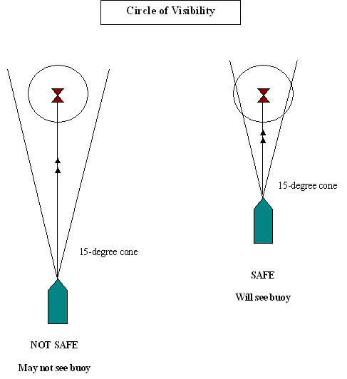
Circle of Visibility
|
In
times of low visibility, it is often difficult to find a mark.
1. Determine
the distance of visibility for an object subject to the current
conditions.
2. Draw a
circle around the mark equal to the area of visibility.
3. Plot a
course to the mark.
4. A boat
normally sails 7 - 8 degrees to either side of a track line creating a
cone of 15 degrees.
5. Plot a 15
degree arch from the boat on either side of the track line.
6. The cone
must pass within the circle of visibility of the mark if you expect to
see the mark. |
|
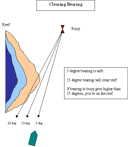
Clearing Bearing
|
When it
is necessary to stay clear of a reef or an underwater obstruction,
calculate three bearings to the mark: safe, clear, danger.
By knowing these bearings, you can
sail to the mark and only be concerned that the mark stay below the
unsafe bearing you calculated.
In the example to the
right, as long
as the mark does not go higher than 15 degrees, you are okay. It
must remain between 15 & 5 degrees for you to reach the mark
safely. If it goes to 25 degrees, you're on the reef. |
|
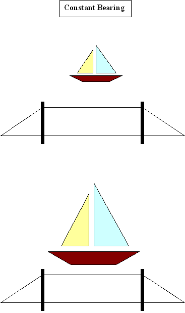
Constant Bearing
| When
the compass bearing of another boat remains unchanged but the boat
continues to get closer, you are on a collision course.
You can use the
lifelines and stanchions (or any other stationary object onboard) to
align with the boat in order to gauge its bearing change. If it
remains aligned with the object and continues to get closer, you should
consider altering course. |
|
Frozen Range
|
Leading Mark
|
| If
an object doesn't move fore or aft with respect to the shoreline, the
boat is moving directly toward the object. |
It
is better and easier to steer toward a mark rather than try to steer a
compass course. |
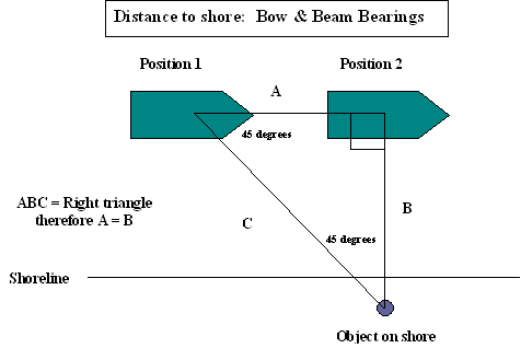
Estimating Distance from Shore
Bow & Beam Bearings
1.
Record the time when a charted object onshore is 45 degrees from the boat.
2.
Record the time when the object is abeam of the boat (i.e. 90 degrees).
3.
The distance traveled (A) computed from time and speed is the distance
from the object (B). |
|
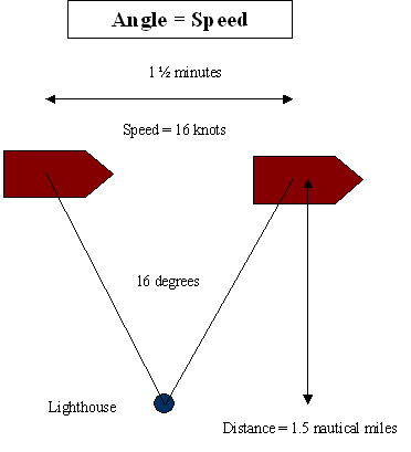
Angle = Speed
1.
Take a bearing with a hand bearing compass as you pass a charted object
onshore.
2.
Record the time in minutes that it takes the bearing change to equal the
boat speed in knots.
3.
The time in minutes will equal the distance from the object in nautical
miles.
4.
If you combine the calculation with a line of position from the object
to the boat, it provides you with a good estimated position.
|
|
Finding an Estimated Position using a
GPS
| Set
a waypoint at your starting point when beginning a voyage, and
continue setting waypoints at each turn in the voyage. You will
then be able to refer back to these waypoints and use them to help
establish an estimated position. It is also helpful if you
already know the waypoint of your destination.
1. Use the GPS to
determine the direction and bearing of two or three prior waypoints.
2. Draw lines of
position from these waypoints.
3. Where they intersect
is your estimated position. |
Navigation Strategies
|
1. |
Plan
to arrive upwind or up current. |
| 2. |
When
possible, take the favored tack. The favored tack is the one that
takes you closer to your destination. You should always start on
the favored tack when beating upwind. That way, if the wind unfavorably
alters course, you will have gained some ground at the start. |
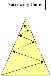
| 3. |
| Upwind
Tactics.
When beating
upwind, do so in a narrowing cone.
Beating upwind
increases the distance by 1/3. |
|
|
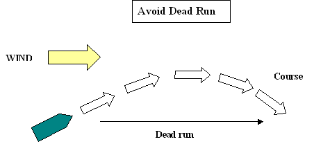
| 4. |
| Downwind
Tactics.
Avoid dead run
with the wind behind you.
Alter course
35 degrees from rhumline. The extra speed may make up for
the extra distance traveled. |
|
|
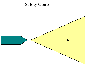
Heavy Weather Tactics
| 1. |
| Safety
Cone
Assume a 20
degree cone (10 degrees on each side.
Don't let the
cone pass too close to any obstructions. |
|
|
| 2. |
Circle
of Probability
Draw a circle of error
around a dead reckoned position.
Assume you are in the
circle in the position closest to danger. |
| 3. |
Taking
a Bearing
When the weather is
too rough to site a hand bearing compass, aim the boat at the mark and
record the bearing using the binnacle compass.
Likewise, steer abeam
of the bearing and record the bearing using the boat's binnacle compass. |
| 4. |
Leeway
An average 35 foot
sailboat sailing close hauled will experience leeway up to 7 degrees in
20 knot winds.
It will experience
leeway of not less than 10 degrees in 30 knots of wind. |
|